Hint: it’s exactly who you think, but it’s not that simple.
A viral video released in late October asked a straightforward question that any grade schooler should be able to answer: Who owns the Statue of Liberty – New York or New Jersey? As it turns out, the answer is not as simple as saying “New York” and moving on.
Since we’re mapping nerds, what followed after we discovered the video was an endless forwarded email chain and a deep dive by our content marketing specialist into historically contested state borders. It was wild.
The video explores a dispute between New York and New Jersey over their sea borders that dates back to colonial times. England’s initial delineation between the two colonies was creatively interpreted by both New York and New Jersey, leading to several challenges throughout history, before the current arrangement between the two was reached.
Unsurprisingly, such border contentions in the United States have largely been settled for quite some time. For example, the only Red River battle that Oklahoma and Texas will fight from here on out will be the annual rivalry game between the universities’ football teams, and even then, no land will change hands as a result.
However, it can be extremely important for businesses to understand jurisdictional boundaries between cities, counties, and states for a number of reasons – be they taxation, zoning, or otherwise. This makes it equally important that a location intelligence platform can clearly communicate these administrative boundaries. If you’re working in LandVision™™, here are the different administrative boundaries available to you, as well as the information you will have access to once you’ve selected one.
Access State, County, City, and Zip Code-Level Administrative Boundaries in LandVision™
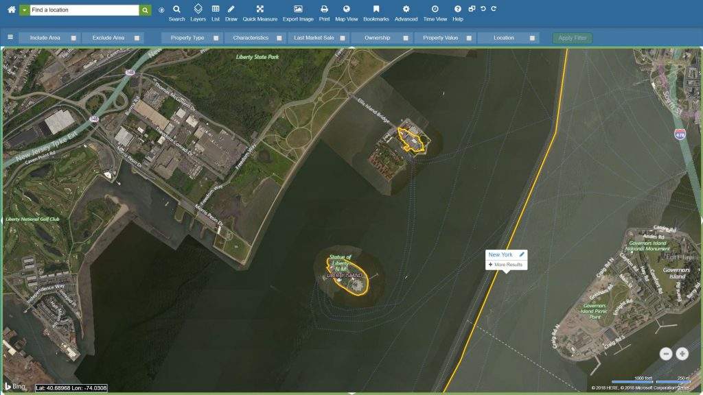
Administrative boundaries can be easily accessed within LandVision™. Simply select the appropriate state, county, city, or zip code boundaries that you would like to overlay and the corresponding lines will appear in your map view. Clicking on a boundary line will display all jurisdictional information relevant to the area (for example, at the zip code level you will see the zip code, county name, and state name), and you can also easily search for properties within the region.

Overlaying state-level administrative boundaries within LandVision™™, it is clear to see that both Ellis and Liberty Islands do indeed fall on the New Jersey side of the line. However, the entirety of Liberty Island and a portion of Ellis Island (“why not all,” you ask? Watch the video!) fall within New York’s borders. So to answer the original question, the Statue of Liberty is situated on federal land within Liberty Island, which is itself the property of New York, but located in… New Jersey waters. Just like you always thought.
This is just one example of the fun that can be had with maps. Of course, LandVision™™ is used for much more than settling territorial squabbles. In fact, over 1,200 businesses and government entities trust LandVision™™ to help them make confident, data-backed decisions with regards to properties. Contact us today if you are interested in learning more, or schedule a demo to see LandVision™™ in action!