
A significant challenge facing many organizations today is enriching first-party data (data they collect from their customers) with third-party data (data obtained by external sources). Data enrichment, the process of enhancing existing data by supplementing it with additional data, faces challenges such as inconsistent address formats and lack of unique identifiers. In our recent blog article, we explored the fundamentals of geocoding, its various applications, and its integration with GIS (geographic information systems). Organizations that rely on accurate location data to make strategic decisions or provide services, such as real estate developers, retailers and logistics companies, often face these challenges. For instance, real estate developers need precise property and parcel information, retailers require accurate customer addresses for targeted marketing, and logistics companies need reliable delivery locations.
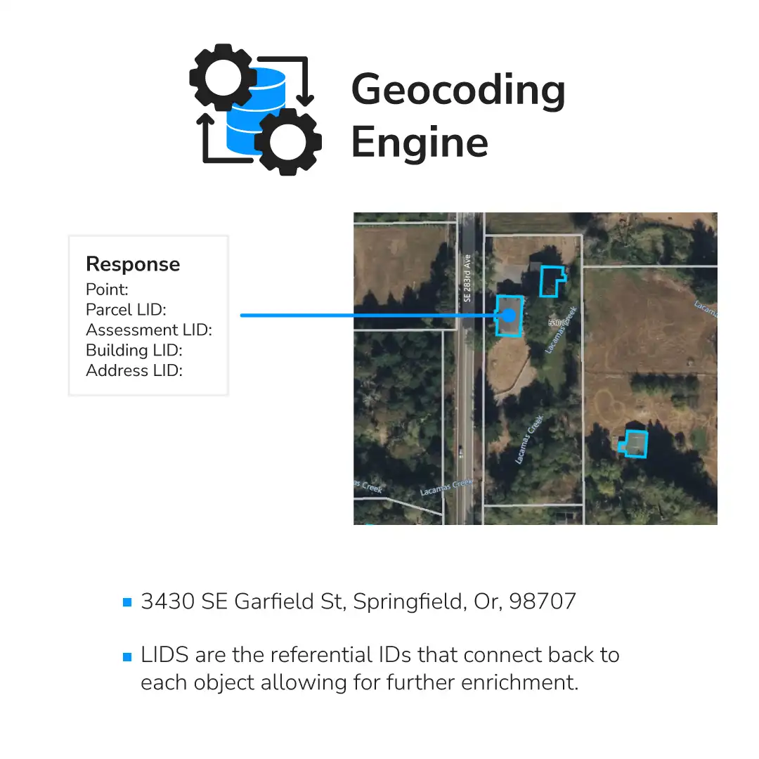
In the figure below, we highlight how using a LightBox ID (LID) can address these challenges, effectively enriching an organization’s dataset.
The Role of Geocoding with Data Enrichment
Millions of individuals rely on geocoding every day. If you’ve ever hailed a ride with Uber or Lyft, scouted properties on Zillow, sought directions on Google Maps, or search for restaurants on Yelp, geocoding is the background function that allows these functions.
Geocoding often starts the data enrichment process by providing a precise address location. Using geocoding with referential IDs, such as parcel or building IDs, helps link datasets to real-world locations, enabling deeper analysis and insights.
How Industry Standard Geocoders Work
Most standard geocoders follow a process of parsing the provided address and then matching it with a known location. Typically, the resulting response includes four components:
- A standardized address
- Location information: This denotes the position on the Earth, represented by longitude and latitude coordinates.
- A confidence score: This score assesses the accuracy of the match between the input address and the matched address.
- A precision code: This code indicates the level of precision in the location information provided.
Evaluating Address Accuracy with Confidence Scores
Input addresses frequently lack uniformity and may be prone to human error when manually entered. The primary objective of a geocoder is to align the provided address with a recognized one. The confidence score, generated by the geocoding service, indicates the level of certainty regarding the accuracy of the match to a valid location. A perfect match yields a confidence score of 100%, while decreasing confidence correlates with a lower score. This score serves as a valuable metric for the calling application’s decision-making process.
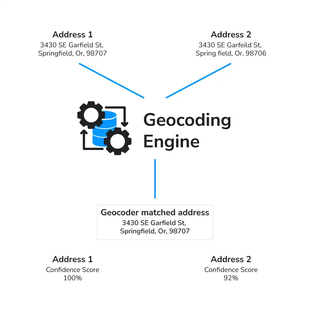
The figure above shows a visual representation of a confidence score and what happens when a user inputs an incorrect address. Address 1 and address 2 are meant to be the same address. Address 2 has an incorrect postal code and a misspelling in the street name. The geocoder will attempt to match the input address and return a confidence score based on how well the matched address matches the input address. In this case, because Address 2 does not match exactly it has a lower confidence score than Address 1.
Address Precision: Why It Matters
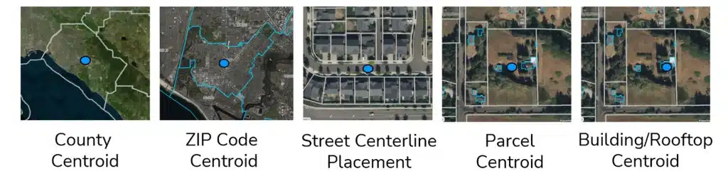
Leveraging the precision code enables your application to gauge the accuracy of the location, which in turn drives business logic. Imagine if you were using Uber and the driver received your location information as in downtown Chicago. You will most certainly be late for your appointment! Thankfully, Uber uses a different set of location information called the building centroid, to give an accurate center point of a particular property, not a center point of a city. Here are the five most common location precisions that geocoders use:
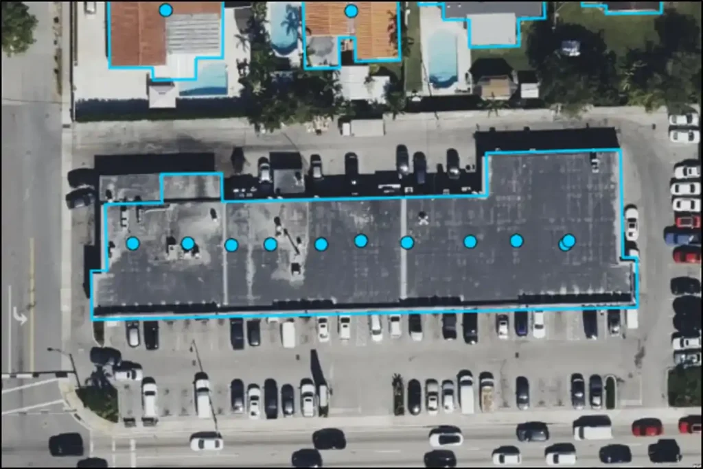
High-Quality Precision for Accurate Deliveries
High-quality precision at the suite level is essential for businesses and organizations that rely on accurate location data like in the logistics industry, where the efficiency of package deliveries within large office complexes or multi-tenant buildings is needed. By pinpointing exact suite numbers within buildings, this level of precision ensures that deliveries, services, and correspondence reach their intended destinations without error. The visual representation below illustrates the benefits of such detailed geocoding, highlighting the accuracy and reliability it provides.
Geocoding the Gateway to Data Enrichment?
By employing geocoding in tandem with referential IDs such as parcel ID or building ID, you can bridge data sets to real-world assets. By inputting addresses into the geocoder and using the returned parcel ID or building ID, you can retrieve this data to enrich your first party data. This approach facilitates the seamless integration of data sets with real-world assets, enabling comprehensive analysis and insights.
Unleashing the Potential of Your Data
LightBox Geocoding is a cloud-based geocoder accessible via a set of APIs available in the LightBox Developer Portal. It efficiently processes addresses from both the U.S. and Canada, delivering highly precise location data. LightBox Geocoding not only standardizes addresses and corrects input errors but also provides Unique Address Identifiers (UAID) for Canadian addresses and LightBox Address IDs for U.S. addresses. Additionally, the LightBox Geocoder returns identifiers linked to real-world assets like parcels, buildings, and assessment data, enabling users to retrieve comprehensive property information associated with the provided address.